
The Quick Version
- Lake Blue Ridge, Georgia is a 3,290-acre TVA reservoir with more than 60 miles of shoreline, about 80 percent of it Chattahoochee National Forest.
- Blue Ridge Dam was finished in 1930. TVA lowers the lake about 22 feet from summer to winter.
- Morganton Point is the only developed campground on the shore; day use is $5 per person.
- Private lakefront is scarce. Most “lake” cabins are lake-view or lake-access.
- Fannin County’s median sale price was $644,500 year-to-date through August 2026.
- Last updated September 2026.
Lake Blue Ridge covers 3,290 acres, and about 80 percent of its shoreline belongs to the Chattahoochee National Forest, according to the U.S. Forest Service. That one fact shapes everything else about the lake: where you can launch a boat, why the ridges stay wooded, and why so few cabins actually touch the water.
I’m Thomas Echea, a Blue Ridge real estate agent and Luxury Real Estate Advisor with E+E Group at Compass. I own in Blue Ridge and spend a good part of my year around this lake. This is the guide I hand to people who are dreaming about it: the access points, what is open when, how the drawdown works, and what the market looks like once the daydream turns into a search.
Who owns Lake Blue Ridge, Georgia, and who owns the shoreline?
Two federal agencies. The Tennessee Valley Authority owns the dam and the reservoir, and the U.S. Forest Service manages most of the land around it. TVA describes Blue Ridge Reservoir as stretching 11 miles southeast from the dam along the Toccoa River, inside the Chattahoochee National Forest.
The split matters. TVA controls the water level and the shoreline and dock permits. The Forest Service controls the campground, the boat ramps, and the wooded slopes you see from the water. Its listing on Recreation.gov puts the shoreline at more than 60 miles, roughly 80 percent of it national forest. The Fannin County Chamber counts 65 miles, about 25 percent developed. Either way, the developed fraction is small and not growing.
Below the dam the river flows northwest toward Tennessee, where it becomes the Ocoee. Above the lake the free-flowing Toccoa is its own kind of frontage, with its own rules, which I cover in the guide to Toccoa River cabins in Blue Ridge.
Where can you get on the water?
Five public or commercial access points, all on the west and north shore. Morganton Point sits about 15 minutes east of downtown Blue Ridge along U.S. Highway 76, per the Forest Service, and the rest cluster along Old Highway 76 and Aska Road.
| Access point | Where | What it offers | Cost, as of 2026 |
|---|---|---|---|
| Morganton Point Recreation Area | 475 Lake Drive, Morganton | Campground, swim beach, picnic area, paved ramp | $5 per person day use, age 16 and up |
| Lake Blue Ridge Day Use Area | Off Aska Road, 2 miles from U.S. 76 | Boat ramp, lakeshore walk, 1-mile paved loop | Free ramp, per the Chamber |
| Lakewood Landing | Old Highway 76, Morganton | Boat ramp | Fee ramp |
| Lake Blue Ridge Marina | Old Highway 76 | Boat sales, storage, rentals, ramp, store | Commercial |
| Blue Ridge Dam recreation area | Old Highway 76 at the dam | Overlook, picnic tables, canoe and kayak launch below the dam | Free |
The lake is open to motorboats, personal watercraft, and paddle craft. The Forest Service asks for a Georgia fishing license and a valid boat registration.
What does Blue Ridge Dam do, and what is the winter drawdown?
It makes power and holds back floods, and the second job is what changes the lake. Construction of Blue Ridge Dam began in 1925 and finished in 1930, per TVA, which has operated it since 1939 according to the Fannin County Chamber. The dam stands 175 feet high and runs 1,553 feet across the Toccoa River, with one generating unit rated at 16 megawatts.
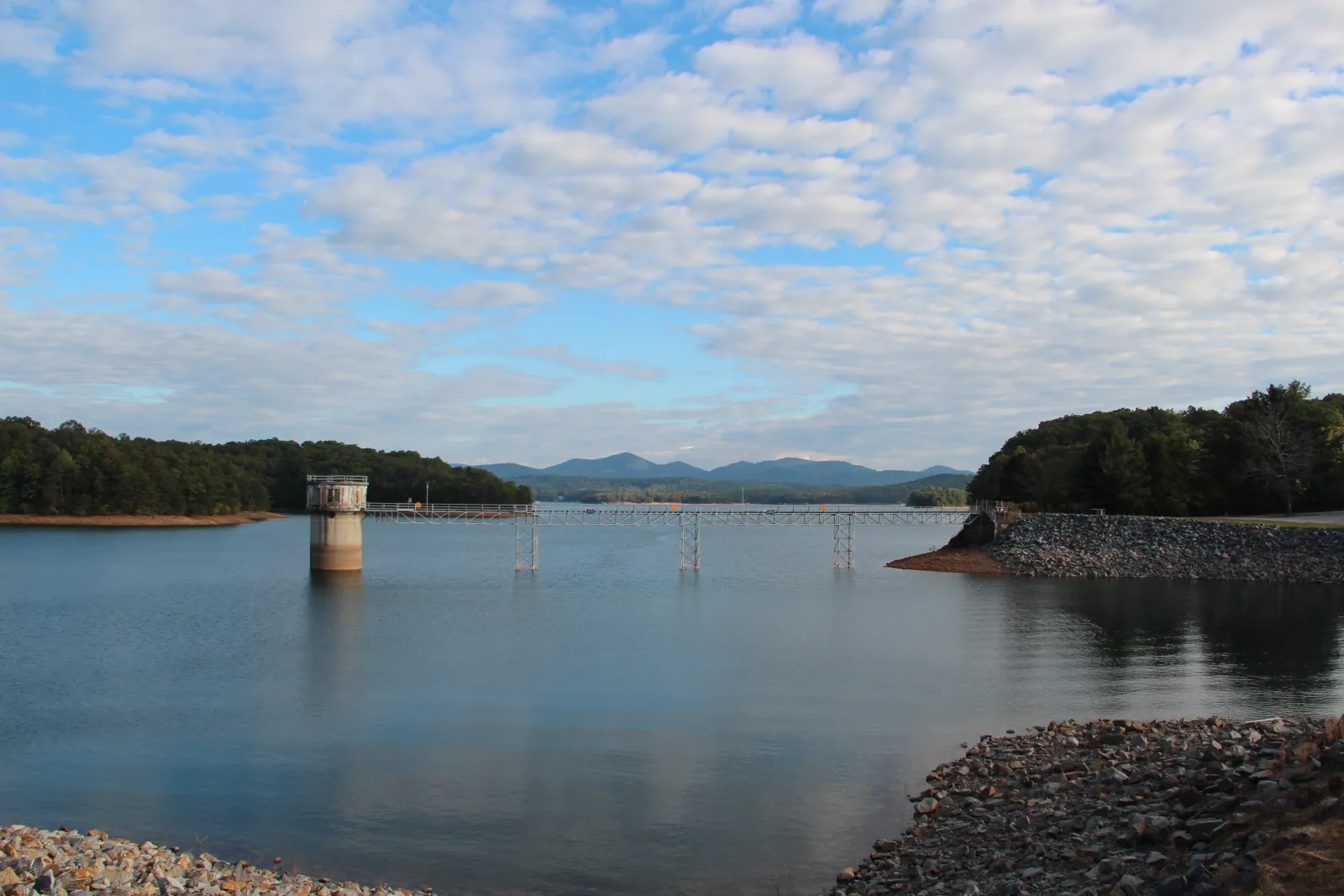
In a year with normal rainfall, TVA says the water level varies about 22 feet from summer to winter to hold flood storage, 68,500 acre-feet of it. That is the drawdown. A cove that floats a pontoon in July shows mud and rock in January, and a dock in deep water in August can sit dry by winter. TVA posts observed and predicted levels daily, and releases can change without notice, so the gauge decides when the boat comes out.
What is the weather like through the seasons in the North Georgia mountains?
Four real seasons and about 60 inches of rain spread across them. The nearest station with full 1991 to 2020 climate normals is the Blairsville Experiment Station, about 1,950 feet up, and its NOAA normals track what you feel on the lake.
| Month | Average high | Average low | Rain |
|---|---|---|---|
| January | 49.4 F | 25.4 F | 5.85 in |
| April | 69.2 F | 40.9 F | 5.15 in |
| July | 84.8 F | 62.1 F | 4.88 in |
| October | 70.4 F | 42.9 F | 4.21 in |
| Full year | 68.5 F | 43.3 F | 60.30 in, plus 3.1 in of snow |
In practice the lake season runs from a mild April into a still-warm October, when the water is high and the highs sit near 70. Snow averages about 3 inches a year, so a four-season cabin here is a question of heat and rain, not plows. October is the driest month on that table, which is why leaf season on the water is so reliable.
Why is the water light blue, and why does it sometimes look green?
Low chlorophyll. TVA has monitored the ecological health of Blue Ridge Reservoir with the same method since 1994, and its most recent published rating, for 2020, was “good.” The monitoring notes that chlorophyll concentrations are typically low in the lake. Less algae in the water column means more clarity, and that clarity over a rocky bottom is what produces the aquamarine color the Forest Service describes.
A greener cast tends to show up in the warm months, when algae grow fastest, and after heavy rain, when runoff carries fine sediment in. Neither is unusual for a reservoir. TVA’s 2020 sediment sampling near the dam found no PCBs or pesticides, and it counted 16 fish species. For any swimming or fish-consumption advisory in effect, the Georgia Environmental Protection Division is the source.
What is the town of Blue Ridge like from the lake?
Close, and useful. Morganton Point to downtown Blue Ridge is about 15 minutes west on U.S. 76, and Blue Ridge sits about 90 miles north of Atlanta, per the Fannin County Chamber. East Main Street holds the restaurants, the shops, and the Blue Ridge Scenic Railway depot, and it is the kind of downtown you can park once and walk.
Morganton, the small town at the lake’s north end, has a convenience store and gas about a mile from the campground. Full grocery runs happen in Blue Ridge. For how the lake towns compare with McCaysville, Mineral Bluff, and Ellijay, see the guide to the towns around Blue Ridge, GA.
Can you actually buy lakefront on Lake Blue Ridge?
Rarely, and that is the honest part of a local’s guide. With about 80 percent of the shoreline in the national forest, private lakefront is a fixed supply. Most cabins marketed with the word “lake” are lake-view or lake-access, with a shared ramp or a community dock. The difference shows up in price and in the drawdown, because a lake-view lot never has to watch its cove go dry.
What do the Fannin County numbers say about the market?
Steady prices, more sales, and plenty of inventory away from the water. Per the Georgia Association of Realtors Local Market Update for Fannin County, the single-family median sale price was $644,500 year-to-date through August 2026, up 2.4 percent from $629,500. Closed sales rose 10.0 percent to 814, homes sold in a median of 86 days, and sellers received 95.3 percent of list price.
Inventory stood at 1,229 homes in August, or 11.2 months of supply, so buyers have choices everywhere except the water’s edge. That is the pattern I see on the MLS week to week: lake-view and lake-access listings move through the normal cycle, and true lakefront trades on its own timeline.
If the water is the point, read the comparison of waterfront in Blue Ridge, river vs. lake before you tour, and price to the comps, not the daydream. If the trails are the point, the Blue Ridge hiking trail guide covers the ground that never comes up for sale.
Frequently asked questions
Where are the best picnic spots on Lake Blue Ridge?
Morganton Point has a picnic area with eight tables and a covered shelter you can reserve, next to the swim beach. The Blue Ridge Dam recreation area on Old Highway 76 has picnic tables and an overlook above the water, and the Lake Blue Ridge Day Use Area off Aska Road is the quiet option, with a one-mile paved loop for a walk afterward.
Can you camp on Lake Blue Ridge?
Yes, at Morganton Point Recreation Area, the only developed campground on the shoreline. The Fannin County Chamber counts 43 sites, 16 of them lakefront, plus two group sites. Reservations run through Recreation.gov up to six months ahead, stays are limited to 14 nights, and quiet hours are 10 p.m. to 7 a.m. The Chamber lists the campground season as April through the end of October.
Is there RV camping near Lake Blue Ridge?
Morganton Point takes both tents and RVs, and the Forest Service lists sites with electric hookups and sites with electric and water. Several walk-in sites are tent only. Each site allows two vehicles, and a boat trailer or a self-propelled camper counts as one of them.
Are there hiking trails near Lake Blue Ridge?
Yes. Morganton Point has short day-use trails, including one that follows the lakeshore, and the Day Use Area off Aska Road has a shoreline walk and a one-mile paved loop. The Aska Trail System, with 16.5 miles of trail, drops to the lake from Aska Road, and the Appalachian and Benton MacKaye trails both pass through Fannin County.
Why does Lake Blue Ridge turn green, and is it safe?
The green cast usually comes from warm-season algae growth or from sediment washed in after heavy rain, and both are normal for a reservoir. TVA rated the lake’s ecological health “good” in its most recent published assessment, with typically low chlorophyll and no PCBs or pesticides detected in sediment. Check the Georgia Environmental Protection Division for any current advisory.
What is four-season living like on Lake Blue Ridge?
Summer highs average about 85 degrees and January lows about 25, with roughly 60 inches of rain a year and about 3 inches of snow, per NOAA normals from the nearest full station in Blairsville. The bigger seasonal change is the water itself: TVA lowers the lake about 22 feet from summer to winter, so lake-view owners and lakefront owners have different winters.